Loggers Lake
Monday, July 31, 2006
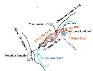
Loggers Lake is a small body of water in an old volcanic cone. This attractive destination allows you to enjoy one side of the Cheakamus River on the way up and the other coming down. We decided to make it our objective for today.
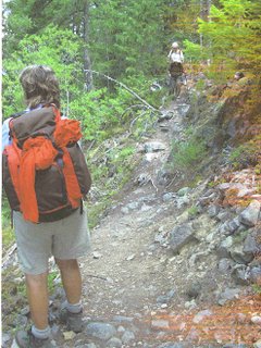
 Meeting at St. David’s Church at 8 o’clock, we set off on the Sea-to-Sky Highway. After some minor delays for construction, we arrived at Millar Creek Café at Function Junction about 9:30. After the refreshment break, we drove a kilometre up the road towards Whistler’s garbage disposal site and parked just across the Cheakamus bridge. From here we started off up Riverside Trail, following Cheakamus River’s southern bank for about two and a half kilometres (with various up and down sections) until it reaches MacLaurin Bridge - a pedestrian suspension bridge across the river. The blue and white glacier waters were rushing down the canyon below as we took a morning break before moving on. Three cyclists came by as we were resting, this being a popular cycling route.
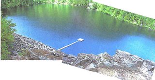
 Continuing on the trail, we came to Loggers Lake’s parking area, crossed Westside Main and made our way up the hill opposite towards the lake. En route, we met three returning fishermen, with inflatable rafts, who had caught some rainbow trout in the lake. Shortly before the lake, we turned left and followed Crater Rim Trail. This went fairly steeply up, offering views over the lake below, and we carried on to reach Lava Lookout. Here we had views over the east-west Cheakamus Valley below and across towards the north and the home of Cheakamus Lake which gathers its water from the surrounding glaciers. The Lookout was a great spot for an extended lunch break.
 We came back on a short cut which set off from opposite the Lookout notice board. The trail was somewhat bushy with overgrowing alders but it offered a quick way back to the lake edge. Turning left at the bottom, we went around the lake clockwise, catching occasional glimpses of the rim trail we had taken up. At the MacLaurin bridge we took a short breather before crossing and heading back down on the east side. The notices on the east side were out of date, as the trail has been extended all the way to the bottom since they were posted. We took a final refreshment stop at a river viewpoint just before the bottom and reached our car in about ten minutes more.
 Return to Further Walks
Meeting at St. David’s Church at 8 o’clock, we set off on the Sea-to-Sky Highway. After some minor delays for construction, we arrived at Millar Creek Café at Function Junction about 9:30. After the refreshment break, we drove a kilometre up the road towards Whistler’s garbage disposal site and parked just across the Cheakamus bridge. From here we started off up Riverside Trail, following Cheakamus River’s southern bank for about two and a half kilometres (with various up and down sections) until it reaches MacLaurin Bridge - a pedestrian suspension bridge across the river. The blue and white glacier waters were rushing down the canyon below as we took a morning break before moving on. Three cyclists came by as we were resting, this being a popular cycling route. Continuing on the trail, we came to Loggers Lake’s parking area, crossed Westside Main and made our way up the hill opposite towards the lake. En route, we met three returning fishermen, with inflatable rafts, who had caught some rainbow trout in the lake. Shortly before the lake, we turned left and followed Crater Rim Trail. This went fairly steeply up, offering views over the lake below, and we carried on to reach Lava Lookout. Here we had views over the east-west Cheakamus Valley below and across towards the north and the home of Cheakamus Lake which gathers its water from the surrounding glaciers. The Lookout was a great spot for an extended lunch break.
 We came back on a short cut which set off from opposite the Lookout notice board. The trail was somewhat bushy with overgrowing alders but it offered a quick way back to the lake edge. Turning left at the bottom, we went around the lake clockwise, catching occasional glimpses of the rim trail we had taken up. At the MacLaurin bridge we took a short breather before crossing and heading back down on the east side. The notices on the east side were out of date, as the trail has been extended all the way to the bottom since they were posted. We took a final refreshment stop at a river viewpoint just before the bottom and reached our car in about ten minutes more. Return to Further Walks
Archives
![]()